A coalition of African nations is spearheading an international movement to replace the centuries-old Mercator world map with more accurate cartographic representations. The initiative aims to correct what advocates describe as systematic underrepresentation of the African continent’s true scale.
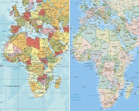
The Mercator projection, developed in the 16th century primarily for maritime navigation, has long been criticized for distorting landmass sizes. This mathematical distortion significantly enlarges territories in northern latitudes while reducing the apparent size of equatorial regions. Africa, despite being the world’s second-largest continent, appears substantially smaller than its actual dimensions under this system.
“This isn’t merely about cartographic accuracy,” explained one senior African diplomat involved in the campaign. “The persistent use of distorted maps perpetuates misconceptions about Africa’s significance and scale, affecting everything from educational materials to international policy discussions.”
The movement has gained formal backing from the continental political body representing African states, which has endorsed the adoption of the Equal Earth projection. This newer map system, developed in 2018, maintains proportional accuracy in representing land areas without the polar exaggeration characteristic of the Mercator method.
Educational reformers note that introducing accurate maps in classrooms could significantly impact how young Africans perceive their continent’s global position. “When children repeatedly see their homeland represented as smaller than its true size, it subtly undermines geographical understanding and cultural pride,” commented an education specialist working on curriculum development.
The campaign has extended beyond African borders, receiving support from Caribbean nations and international development organizations. Critics of the traditional mapping system argue that the Mercator projection reflects historical power dynamics that continue to influence global perceptions.
While some major technology companies have begun transitioning away from exclusive use of the Mercator system, the projection remains widely employed in digital mapping applications and educational materials. International organizations are now reviewing mapping standards, with several already implementing alternative projections for official documents and publications.
The mapping initiative forms part of broader efforts to recalibrate global representations of Africa, coinciding with increasing discussions about historical legacy and contemporary international relations. Proponents argue that accurate geographical representation represents a fundamental step toward rectifying longstanding misperceptions about the continent’s scale and importance.